Design Uber: Ride Matching, Location Tracking and Pricing
Solve the Uber system design interview: real-time location updates, driver matching, geospatial indexing, trip state, pricing, scale, and tradeoffs.
Quick answer: Design Uber: Ride Matching, Location Tracking and Pricing
Design Uber: Ride Matching, Location Tracking and Pricing is covered here as a practical system design interview problem. Solve the Uber system design interview: real-time location updates, driver matching, geospatial indexing, trip state, pricing, scale, and tradeoffs. Use it to practice requirements, APIs, storage choices, scaling bottlenecks, data consistency, observability, and failure handling for a hard interview round.
Focus on the problem being solved, the main design choice, the failure mode, and the tradeoff you would defend in front of a senior engineer. This page is part of the DosiBridge system design knowledge graph, so it links related concepts, interview problems, tradeoffs, and references instead of leaving the topic isolated.
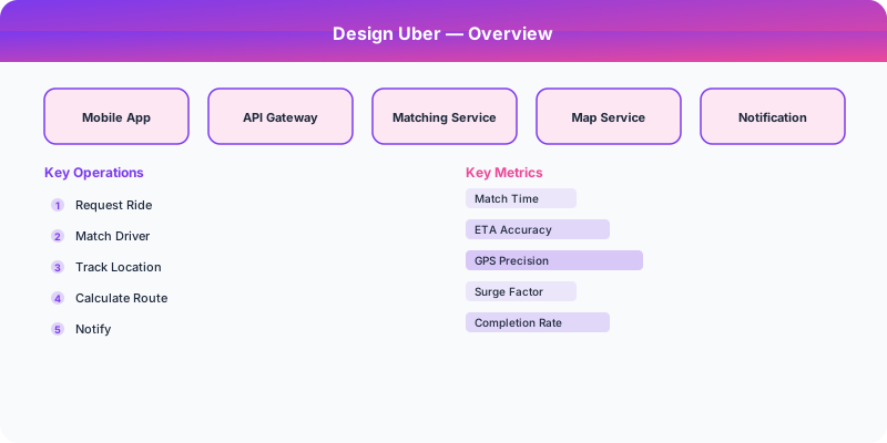
Problem Statement
Design Uber: Ride Matching, Location Tracking and Pricing as a production service where growth exposes the first weak assumption in the original design. For Design Uber: Ride Matching, Location Tracking and Pricing, name the critical user action, the data that must remain correct, and the first bottleneck that appears when traffic grows.
Deep-Dive: Clarifying Questions for Uber
- What geographic coverage? Global (900+ cities) or a single city? Global requires geo-distributed architecture with regional data residency.
- How do we match riders to drivers? Nearest available driver? Best ETA? Consider traffic, driver rating, surge pricing? The matching algorithm is the core intellectual property.
- What is the location update frequency? Drivers send GPS updates every 3-4 seconds. With 5 million active drivers, that is 1.25-1.67 million location updates per second.
- Do we need surge pricing? Dynamic pricing based on supply/demand ratio requires real-time market-making computation.
- What geospatial indexing do we use? Google S2, Uber H3, or traditional geohashing? This choice affects query efficiency and precision.
- How do we handle real-time tracking? Riders need to see their driver approaching in real-time. This requires pushing location updates to specific rider apps via WebSocket connections.
Specific Functional Requirements
- Ride Request: Rider specifies pickup and dropoff locations, selects ride type (UberX, XL, Black), sees price estimate
- Driver Matching: System matches the rider with the best available driver based on ETA, proximity, and other factors
- Real-Time Tracking: Both rider and driver see each other's location updating in real-time during the ride
- ETA Estimation: Predict pickup time and trip duration using historical traffic data, real-time conditions, and road graphs
- Surge Pricing: Dynamically adjust prices based on local supply (available drivers) and demand (ride requests) ratios
- Payment Processing: Automatically charge the rider after trip completion with fare breakdown
- Rating System: Both riders and drivers rate each other after each trip
Specific API Endpoints
POST /api/v1/rides/estimate
  Body: { "pickup": { "lat": 37.7749, "lng": -122.4194 }, "dropoff": { "lat": 37.3382, "lng": -121.8863 }, "ride_type": "uberx" }
  Response: { "estimated_fare": "$23-28", "estimated_pickup": "4 min", "estimated_trip": "42 min", "surge_multiplier": 1.0 }

POST /api/v1/rides/request
  Body: { "pickup": {...}, "dropoff": {...}, "ride_type": "uberx", "payment_method_id": "pm_abc" }
  Response: { "ride_id": "ride_123", "status": "matching", "driver": null }

WebSocket /ws/rides/:ride_id/track
  Messages: { "type": "location_update", "lat": 37.77, "lng": -122.41, "heading": 180, "eta_seconds": 120 }

PUT /api/v1/drivers/location
  Body: { "lat": 37.7749, "lng": -122.4194, "heading": 90, "speed": 35 }
  (Called every 3-4 seconds by driver app)

Specific Data Model
Driver Location Store (Real-time): Use an in-memory geospatial index. Uber uses H3 hexagonal grid cells: driver locations are indexed by H3 cell ID (resolution 7, approximately 5 km2 hexagons). When a ride request comes in, search the pickup location's H3 cell and adjacent cells for available drivers.
| Store | Key | Value |
|---|---|---|
| Driver Locations (Redis) | h3_cell_id | Set of (driver_id, lat, lng, status, last_updated) |
| Active Rides (PostgreSQL) | ride_id | rider_id, driver_id, pickup, dropoff, status, fare, timestamps |
| Driver Profiles | driver_id | name, vehicle, rating, documents, status |
| Trip History | trip_id | All trip details, route taken, fare breakdown |
Geospatial Indexing with H3: Uber created the H3 library for hexagonal hierarchical geospatial indexing. Hexagons tile the Earth's surface uniformly (unlike rectangular grid cells), and each hexagon has 6 equidistant neighbors. This makes proximity searches efficient: find all drivers in the target cell and its 6 neighbors (7 lookups total, regardless of geographic area).
Specific Back-of-the-Envelope Numbers
Traffic:
- 20 million rides per day globally (Uber's reported number)
- 5 million active drivers sending location updates every 4 seconds = 1.25 million location updates/second
- Ride matching: 20M rides/day = ~230 ride requests/second average, peaking at 3-5x = ~1,000/second
Storage:
- Driver location updates: 1.25M/sec * 50 bytes = 62.5 MB/second = 5.4 TB/day of raw location data
- Active driver locations (in-memory): 5M drivers * 100 bytes = 500 MB (fits in RAM easily)
- Trip history: 20M trips/day * 2 KB = 40 GB/day = ~14 TB/year
Matching latency target:
- Under 10 seconds from ride request to driver assignment
- Under 3 seconds for the geospatial search component
- Driver location must be under 4 seconds stale
Map/routing:
- ETA calculation uses precomputed road graphs with real-time traffic overlays
- Route calculation: Dijkstra or A* on road graph, under 100ms per route
Original DosiBridge notes for Design Uber: Ride Matching, Location Tracking and Pricing
This section is written specifically for this page, not copied from a general system-design checklist. The useful way to study Design Uber: Ride Matching, Location Tracking and Pricing is to connect the concept to a production service where growth exposes the first weak assumption in the original design. That framing changes the design discussion from definitions to operating choices.
What makes this topic distinct
- Core Entity: For Design Uber: Ride Matching, Location Tracking and Pricing, decide the core entity before choosing tools; otherwise the design looks clean but fails when uber changes.
- Read/Write Path: For Design Uber: Ride Matching, Location Tracking and Pricing, decide the read/write path before choosing tools; otherwise the design looks clean but fails when uber changes.
- Contention Point: For Design Uber: Ride Matching, Location Tracking and Pricing, decide the contention point before choosing tools; otherwise the design looks clean but fails when uber changes.
- Abuse Path: For Design Uber: Ride Matching, Location Tracking and Pricing, decide the abuse path before choosing tools; otherwise the design looks clean but fails when uber changes.
- Recovery Workflow: For Design Uber: Ride Matching, Location Tracking and Pricing, decide the recovery workflow before choosing tools; otherwise the design looks clean but fails when uber changes.
Design Uber: Ride Matching, Location Tracking and Pricing correctness boundary
For this problem, separate the user-visible action from background work. The correctness boundary is the smallest state transition that must not be duplicated, lost, or reordered. Naming that boundary makes the solution more original than a stock API/database/cache template.
Design Uber: Ride Matching, Location Tracking and Pricing scaling bottleneck
The first bottleneck should be described in the language of this system: a hot timeline, a contested seat, a busy wallet ledger, a media-processing queue, or a search index update delay. That bottleneck decides which component deserves the deepest interview discussion.
Production review question
If Design Uber: Ride Matching, Location Tracking and Pricing suddenly receives 10x traffic, which entity becomes contested first, and what queue, lock, shard, or cache protects that entity without hiding correctness bugs?
Practical metric to track
Track uber health as a named dashboard or review item: combine one user-facing metric, one saturation metric, and one correctness metric. For Design Uber: Ride Matching, Location Tracking and Pricing, this keeps the discussion grounded in behavior that can be measured after deployment instead of generic advice that sounds good in an interview but never gets verified.
Sources
Unique design focus: real-time dispatch and trip state
A strong Uber design answer is not a generic location app. The core problem is matching riders and drivers under changing location, supply, demand, payment, and cancellation conditions. The system must make a decision in seconds while thousands of phones constantly update their position.
Core entities
- Driver: availability, current geohash, vehicle type, rating, active trip, last heartbeat.
- Rider: pickup, destination, payment status, request state.
- Trip: requested, matching, offered, accepted, arriving, in-progress, completed, cancelled.
- Dispatch offer: driver candidate, expiry time, rank score, and rejection reason.
Matching flow
- Rider submits pickup and destination.
- Pricing service estimates fare and surge multiplier.
- Dispatch service queries nearby available drivers by geospatial cell.
- Candidate ranking considers distance, ETA, vehicle type, acceptance rate, current traffic, and fairness.
- The top driver receives an expiring offer.
- If accepted, the trip state moves forward and the driver becomes unavailable for new requests.
- If rejected or expired, the system tries the next candidate without duplicating the rider request.
Data and infrastructure choices
- Use geohash/S2/H3 style indexing for nearby-driver lookup.
- Store hot driver locations in memory or a fast geo-capable store, not only in the primary relational database.
- Persist trip state transitions durably because payments, support, and compliance depend on them.
- Use events for 'TripRequested', 'DriverOffered', 'DriverAccepted', 'TripStarted', and 'TripCompleted'.
- Use idempotency keys for rider requests and payment capture.
Failure handling
If the location stream is delayed, use last-seen timestamps and avoid offering stale drivers. If payment pre-authorization fails, do not dispatch. If a driver accepts but the rider cancels, release the driver and emit a cancellation event. If the dispatch service is overloaded, degrade by widening search radius more slowly or showing longer wait estimates instead of silently losing requests.
Interview tradeoff
Optimizing for the absolute nearest driver can be worse than optimizing for reliable acceptance and marketplace balance. A senior answer explains how dispatch ranking balances pickup ETA, driver fairness, cancellation probability, surge areas, and system stability.